


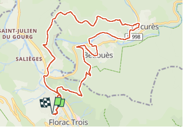
Florac - Cocurès- Bédouès- Lempézou - Florac

cordierlavenant
User

Length
13.4 km

Max alt
779 m

Uphill gradient
497 m
Km-Effort
20 km

Min alt
537 m

Downhill gradient
498 m
Boucle
Yes
Creation date :
2025-07-15 06:32:01.108
Updated on :
2025-07-15 10:22:01.577
3h49
Difficulty : Medium

FREE GPS app for hiking
 SityTrail
IGN / Geographical institutes
SityTrail Plus
The world is yours!
About
Trail Walking of 13.4 km to be discovered at Occitania, Lozère, Florac Trois Rivières. This trail is proposed by cordierlavenant.
Positioning
Country:
France
Region :
Occitania
Department/Province :
Lozère
Municipality :
Florac Trois Rivières
Location:
Florac
Start:(Dec)
Start:(UTM)
546945 ; 4908359 (31T) N.
Comments